


The Meteorological Department warns of typhoon “Koguma” to land in Vietnam, causing rain in 4 regions.
meteorological department Issued the warning of the Koguma Phayao No. 7 on June 13, stating that the storm was coming ashore in Vietnam. As a result, the northern and northeastern regions experienced heavy to very heavy rainfall in some places.
The meteorological department announced that at 4.00 am (June 13, 64) tropical storm “Koguma” in the Gulf of Tonkin. Vietnam Centered at latitude 19.8 degrees north, longitude 106.1 degrees east, it is moving west at about 15 kilometers per hour. The maximum wind speed near the center is about 65 kilometers per hour. It is expected to move ashore in upper Vietnam this morning. This effect causes the monsoon trough to lie across the upper part of the North and the upper Laos. causing heavy to very heavy rainfall in some areas in the North and Northeast Mae Hong Son, Chiang Mai, Chiang Rai, Phayao, Nan, Phrae, Uttaradit, Phitsanulok, Phetchabun, Loei, Nong Khai, Bueng Kan, Nong Bua Lamphu, Udon Thani, Sakon Nakhon, Nakhon Phanom, Kalasin, Mukdahan, Khon Kaen, Maha Sarakham, Roi Et, Yasothon, Amnat Charoen, Sisaket and Ubon Ratchathani. People in the area should beware of the impact of heavy rain and cumulative rain that may cause flash floods. and the flow of wild water as well
Therefore, people are asked to follow the announcement from the Meteorological Department. and can follow the information at the Meteorological Department website http://www.tmd.go.th or at 0-2399-4012-13 24 hours a day.
while the Meteorological Department The weather forecast for June 13 states that general weather Forecast for the next 24 hours The monsoon trough lies across the upper part of the North and the upper Laos. Entering Tropical Storm “Koguma” in the Gulf of Tonkin Vietnam In addition, the strong southwest monsoon still prevails over the Andaman Sea, Thailand and the Gulf of Thailand. Northeastern, Eastern and Southern West Coast There was heavy to very heavy rain in some places. People in the area should be aware of the dangers of heavy rain and accumulated rain during this period. The wind waves in the Andaman Sea and the upper Gulf of Thailand are strong. The Andaman Sea has a wave height of 2-3 meters and an area with thunderstorms with a wave height of more than 3 meters, while the upper Gulf of Thailand has a wave height of about 2 meters, and an area with thunderstorms with a wave height of more than 2 meters. The upper Gulf of Thailand should increase caution in navigation. Small boats in the upper Andaman Sea should stay ashore during this period.
Incidentally, tropical storm “Koguma” in the Gulf of Tonkin Vietnam The monsoon trough is expected to move ashore in upper Vietnam this morning (June 13, 20). make the northern area And the northeast has heavy to very heavy rains in some places.
small dust During the rainy season, the accumulation of dust/smog is minimal.
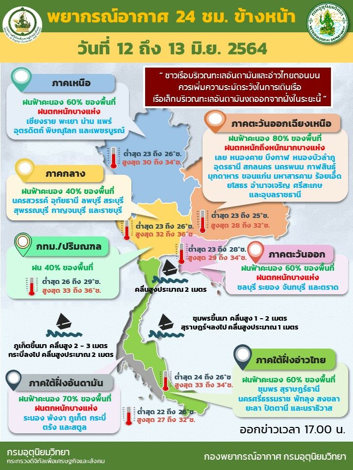
Weather forecast for Thailand from 6:00 AM today until 6:00 AM tomorrow.
North 70 percent of the area’s thunderstorms with heavy to very heavy rain in some places. Mae Hong Son, Chiang Mai, Chiang Rai, Phayao, Nan, Phrae, Uttaradit, Phitsanulok and Phetchabun. Minimum temperature 23-26 C. Maximum temperature 29-33 C. Southwesterly winds, speed 10-25 km/hr.
northeastern region 80 percent of the area’s thunderstorms with heavy to very heavy rain in some places. Loei, Nong Khai, Bueng Kan, Nong Bua Lamphu, Udon Thani, Sakon Nakhon, Nakhon Phanom, Kalasin, Mukdahan, Khon Kaen, Maha Sarakham, Roi Et, Yasothon, Amnat Charoen, Sisaket and Ubon Ratchathani Minimum temperature 23-25 C. Maximum temperature 28-32 C. Southwesterly winds 10-25 km/hr.
central 40 percent of thunderstorms of the area, mostly in Nakhon Sawan, Uthai Thani, Lop Buri, Saraburi, Suphan Buri, Kanchanaburi and Ratchaburi, minimum temperature 23-26 degrees Celsius, maximum temperature 33-35 degrees Celsius, southwesterly winds, speed 10-25 km/hr.
eastern region 60 percent of the area’s thunderstorms with isolated heavy rain. In Chonburi, Rayong, Chanthaburi and Trat, minimum temperature 24-28 C. Maximum temperature 28-34 C. Southwesterly winds 20-35 km/hr. Wave height about 2 meters. 2 meters
Southern (East Coast) 40 percent of thunderstorms of the area, mostly in Chumphon, Surat Thani, Nakhon Si Thammarat, Phatthalung, Songkhla, Yala, Pattani and Narathiwat, minimum temperature 24-26 degrees Celsius, maximum temperature 33-35 degrees Celsius.
From Chumphon upward: Southwesterly winds, speed 15-35 km/hr. The sea has waves 1-2 meters high, about 2 meters offshore.
From Surat Thani downwards: Southwesterly winds 15-30 km/hr. The sea has a wave height of about 1 meter, 1-2 meters offshore.
Southern (West Coast) 60 percent of the area’s thunderstorms with isolated heavy rain. In Ranong, Phang Nga, Phuket, Krabi, Trang and Satun, the lowest temperature 22-26 degrees Celsius, the highest temperature 29-33 degrees Celsius.
From Phuket up: Southwesterly winds 20-40 km/hr. Wave height 2-3 meters in thunderstorm areas, waves higher than 3 meters.
From Krabi down: Southwesterly winds 20-35 km/hr. Wave height about 2 meters in thunderstorm areas, waves higher than 2 meters.
Bangkok and surrounding areas There is rain in 40 percent of the area.
Minimum temperature 26-28 C. Maximum temperature 32-35 C. Southwesterly winds 10-25 km/hr.
